


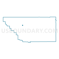
Voting District 10290, Kern County, California
About
Outline

Summary
| Unique Area Identifier | 531698 |
| Name | Voting District 10290 |
| County | Kern County |
| State | California |
| Area (square miles) | 2.58 |
| Land Area (square miles) | 2.58 |
| Water Area (square miles) | 0.00 |
| % of Land Area | 100.00 |
| % of Water Area | 0.00 |
| Latitude of the Internal Point | 35.47039230 |
| Longtitude of the Internal Point | -119.24875240 |
Maps


Graphs
Select a template below for downloading or customizing gragh for Voting District 10290, Kern County, California


Neighbors
Neighoring Voting District (by Name) Neighboring Voting District on the Map
- Voting District 10125, Kern County, CA
- Voting District 10145, Kern County, CA
- Voting District 10150, Kern County, CA
- Voting District 10155, Kern County, CA
- Voting District 10285, Kern County, CA
- Voting District 10291, Kern County, CA
- Voting District 10295, Kern County, CA
- Voting District 10300, Kern County, CA
- Voting District 10350, Kern County, CA
- Voting District 10360, Kern County, CA
- Voting District 10365, Kern County, CA
- Voting District 10370, Kern County, CA
- Voting District 10375, Kern County, CA
Top 10 Neighboring County Subdivision (by Population) Neighboring County Subdivision on the Map
Top 10 Neighboring Place (by Population) Neighboring Place on the Map
Top 10 Neighboring Elementary School District (by Population) Neighboring Elementary School District on the Map
- Richland-Lerdo Union Elementary School District, CA (19,085)
- Rio Bravo-Greeley Union Elementary School District, CA (4,787)
Top 10 Neighboring Secondary School District (by Population) Neighboring Secondary School District on the Map
Top 10 Neighboring State Legislative District Lower Chamber (by Population) Neighboring State Legislative District Lower Chamber on the Map
Top 10 Neighboring State Legislative District Upper Chamber (by Population) Neighboring State Legislative District Upper Chamber on the Map
Top 10 Neighboring 111th Congressional District (by Population) Neighboring 111th Congressional District on the Map
Top 10 Neighboring Census Tract (by Population) Neighboring Census Tract on the Map
- Census Tract 40, Kern County, CA (7,704)
- Census Tract 39, Kern County, CA (2,250)
- Census Tract 42, Kern County, CA (1,320)